Atoll Research Bulletin
(The following was extracted from the Atoll Research Bulletin. Please click the predecing link for much more content from this fabulous document.)
Washington Island (Teraina) in the Northern Line
Islands is a small atoll with a land area of 14.2 sq. km.
situated at 4O 43'N, 160° 25'W. The Northern Line Island
archipelago is comprised of four islands aligned on an axis
which runs from Christmas Island, just north of the equator,
to Palmyra Island in the northwest (Figure 1). Washington
Island, and its nearest neighbor Fanning Island, about 150
kilometers to the south east, have had close economic and
social ties for most of their recent history. The climate of
Washington Island is strongly influenced by intertropical
convergence and has an average annual rainfall of 2902 mm
although Christmas Island, two degrees south, receives only
766 mm.
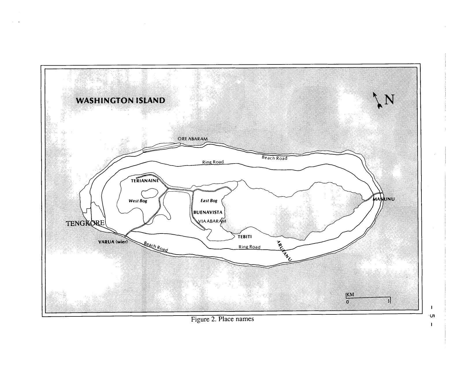
Washington Island is lens-shaped and about 7
kilometers long by about 2 1/2 kilometers across at its widest
point (Figure 2). The interior depression contains a
freshwater lake and peat bogs and the ratio of the area of
land compared to that of the enclosed water body is high.
Similar small islands of this form would include Swains,
Pulusuk and Clipperton Islands. Typically they have narrow
fringing reefs which shelve very rapidly and do not provide
safe anchorages. The Pacific Islands Yearbook describes
Washington Island as 'the most difficult and dangerous loading
port in the pacific' (Carter, 1984:257). The small size and
inaccessibility of this island explains why, despite its
unusual characteristics, it has not been investigated in more
detail.
The first map of Washington Island was produced by
the United States North Pacific Exploring Expedition in 1874
(Figure 3)(Skerrett, 1873-4). Although a commendable
achievement in surveying for its time, it has many
inaccuracies but has been used as a base for most of the
subsequent published maps (Wentworth, 1931; Bryan, 1942;
Tennant and Mutter, 1977; Vitousek, et al., 1980). A map of
the island at a scale of 1:4,800 in the Burns Philp archives
at the University of Sydney shows sections used for harvesting
coconut and was prepared sometime after 1915. Comparison with
aerial photographs and ground observations indicate this map
to be a more accurate representation of the shape of the
island and the lake. Hems (1926) apparently used this as the
base for his maps and we have done the same.
The purposes of this study were to survey existing
vegetation patterns and summarize known information on the
physical environment and history of human occupation as a
basis for understanding the history of vegetation change.
In August 1982 Wester spent two weeks collecting and
surveying vegetation on Christmas and Fanning Islands and a
one day trip was made to Washington island. The following
August the three authors spent two weeks on Washington
Island. A total of nine transects were completed (Figure 4).
These were selected to give typical cross sections of the
island orto characterize particular places or circumstances
and to sample the existing vegetation, topography and the
character of the substrate. Peat samples were taken for
pollen analysis to determine prehistoric vegetation change
especially with respect to the role of coconut in the
vegetation cover since there is uncertainty whether the
species is native or a human introduction to the remote
islands of the Central Pacific (Spriggs, 1980; Ward and Allen,
1980).
PHYSICAL ENVIRONMENT
Resional seolosic settinq, Formation of the Line-Manihiki Ridge, on which the present Line Islands stand, began about 128 million years B.P. and continued until 105 or 80 million B.P. The ridge remained a submarine structure until between 85 and 80 million years ago when a pulse in crustal formation appears to have lifted the basaltic seamounts into the photic zone. Several reefs then developed simultaneously along the entire chain (Jackson and Schlanger, 1976; Schlanger and Premoli-Silva, 1981).Subsequent cooling of the basement material caused slow subsidence which continues to the present. Those reefs able to keep up with the pace of subsidence created the present-day Line Islands, including Washington Island. A glacially induced sea level change during Oligocene time, 25 to 35 million years ago, perhaps resulted in the emergence of these atolls (Schlanger and Primoli-Silva, 1981) although Haggerty (1982) found no evidence for sub-aerial exposure of limestones in the Southern Line Islands.
Each of the Northern Line Islands has a distinctly different form. Christmas Island in the south is essentially a single large landmass enclosing a central lagoon and a few islets. Further north, Fanning is formed by three elongated motus forming the shape of a footprint. Washington Island is much smaller in area than the other two. Its reef platform is oval in shape. The freshwater body in the central depression has no natural connection to the ocean except at low points in the rim where water floods to the sea during time of high rainfall. Palmyra consists of a string of tiny motus in a horseshoe shape which barely protrude above sea level. Still further north is Kingman Reef which is completely submerged at high tide. The progressive decrease in elevation and size of the coral platform from south to north implies a tilt of the ridge or more rapid rate of subsidence to the north.
Terrestrial qeomorpholoav of Washinston Island (a) Shoreline and Beach Ridges
A narrow beach composed of fine to medium sand mixed with swash deposits of coral rubble and reef rock debris surrounds much of washington Island. Exposed patches of beachrock, up to 30 meters long, are found along the southeast and northeast shoreline. Although Wentworth (1931) noted the absence of gravel or shingle around the island's shores, scattered coral rubble and cobble were observed around the eastern end of the island during our investigation. Beach berms (or ridges) around all except the western end of the island are composed of coral rubble, cobble, and shingle typically ranging in size from 5 to 30 centimeters. Occasionally, larger reef blocks are incorporated into these structures. The coarse coral deposits making up the beach ridge may be covered by a layer of sand, with some gravel, especially on the seaward side.
The landward slope of the beach ridge is variable in topography. In some areas, the coarse cobble and shingle slope drops down fairly quickly and levels off at about 1 meter above the reef flat height, where it is overlain with highly organic, peaty material (Figures 5). On the northern and eastern end of the island the band of reef derived material may extend inland up to 400 meters but in the south the beach ridge is narrower but secondary ridges of cobble and shingle protrude through the the peaty soils of the island interior to form a discontinuous rings parallel to the coast. Around some parts of Washington Island, the beach ridge appears to be eroding. At the northeastern end of the island, which is most exposed to the prevailing easterly winds, a rampart is collapsing onto the beach and the root network, formerly helping to bind the ridge together, is exposed.
In places beach berms are poorly developed shallow pools of standing water are found along with freshwater seepage on the adjacent beach. These areas probably allow overflow from the lake and act as a natural control of the lake level.
From the Atoll Research Bulletin. [3]

From the Atoll Research Bulletin. [3]
Along sections of the southern shore fine sand deposits, colonized by Tournefortia shrubs, appear to overlie a series of broad, muted coral gravel and rubble ridges. Beaches of sand increase in width and height towards the western tip of the island as a result of westward shore drift along both the northern and southern shores (Wentworth, 1931). The convergence of the longshore drift patterns at the islandrs western terminus appears to be extending the land area in this direction, as evidenced by the clouds of suspended sand which are observed over the shoaling reef.
The lack of a distinct reef flat, an unstable depositional environment, and rough seas, made it difficult to make and accurate estimate of the extent of the sand deposits at the western end of the island. Wentworth (1931) describes the beach profile as a smooth cycloidal curve reaching a slope of 30 to 40 degrees at its upper end. He estimates its height at 12 to 15 feet, with an overall width of up to 200 feet, which is in accord with our observations. The beach sand deposits extend inland for over 150 meters from the waterrs edge. Their upper surface is increasingly stained by organic material with distance inland from the open beach. Steep berms, with wide ridgetops elevated about three meters above the reef flat, extend along the northwest and southwest sectors of the island. The backslope of the sand berm slopes down gradually until, at about 1.5 meters, it is ovelain by muds and organic peats.
(b) Inland Beach Ridge and Peat Complex
On the west and southern side of the island the profiles reveal a series of concentric coral and rubble ridges which are presumed to be old beach ridges comparable to those found along parts of the present coast. In low areas, immediately behind the coastal beach berm, localized depressions may be filled with a soft, red-black to black mud, sometimes mixed with small amounts of sand or coarse coral rubble (Figure 5). Between the coral rubble ridges the land slopes gently towards the lake but lies between 1 and 1.5 meters above the adjacent reef flat. These areas are covered by tough fibrous peat-like material under coconut forest which is drier and firmer than the material which forms the substrate to the bog. The surface is lower than the reef deposit ridges, but 10 to 40 cm higher than the adjacent peat bog. Some lower lying sections hold standing water and may, at least in some cases, be abandoned babai pits or other excavations.
Along the northern side of the island, concentric ridges separated by peaty soils are not so evident. Instead there is a broad and slightly irregular platform 200 to 400 meters wide, formed of rubble and reefs of phosphate rock (Figures 7 and 8, Transects 1C and 7). The surface slopes gently towards the interior and until peat soils are encountered at a level of 1 to 2 meters above the reef flat, and extend inland to the lake or bog. In a few areas, the peat soils are found on gentle rises which stand as high as the rubble ridges along the shore (Figure 8, Transects 7). The forested islet in the western bog also seems to lie on a slight rise or irregularity in the underlying reef platform as we found the contact zone between the peats and the lagoon sediments below to be slightly higher under the islet than under the bog.. This suggested to us that the islet may reflect an underlying structural feature of the former reef (Figure 5, transect lb). Christophersen (1927, see his Figure 9) believed that the 'bottom of the peattt was lower under the island than the surrounding bog, and also that the forested peat soil, was lower than the open bog. All our profiles suggest the dominant trend of the land surface in the island interior is downwards to the open bog community or lake shore. In this case also our findings do not agree with the those of Christopherson and we found no evidence of the raised peat sill or levee which enclosed the bog.
(c) Phosphate Soil and Phosphate Rock Where Pisonia srandis trees occur on Washington Island, phosphatic hardpan and soils are found. The occurrence of phosphate rock in association with Pisonia trees, the chemical reactions involved, and the soils which result, are described by Fosberg (1954, 1957). On Washington Island, Pisonia, mixed with other species in varying amounts, is found around much of the island's perimeter. Some large trees even occur immediately behind the beach ridge crest. Phosphatized sand, rubble-sized phosphate, and larger phosphatic rocks orsolid outcrops occur in association with Pisonia areas on the island.
Extensive sheets of phosphate rock hardpan are found at the surface in the Pisonia forest at the east end of the island and in the Pisonia and breadfruit forest just north of Tengkore village, at the islandts west end. The large Pisonia woodland between the two bogs contains massive weathered phosphate blocks and outcrops, the upper surface of some reaching almost 1 meter above the surrounding ground level. Above surface phosphate is ascribed by Fosberg (1954) to have been pushed up by Pisonia root systems or heaved up by the roots of falling Pisonia trees. This explanation seems less plausible in this particular situation because of the amount of sub-aerial phosphate rock present, the size of the formation, and its height above ground level. However, no alternative explanation is proposed.
In any case, the presence of phosphatic rock material in conjunction with Pisonia trees leads to the development of particularly rich atoll soils, described by Fosberg (1954) as the Jemo series. The occurrence of phosphate rock on a very wet island such as Washington, is not well understood since most wet islands lack phosphate deposits altogether. As Stoddart (1983) points out, the distribution of phosphate rock suggests a variety of environments or complex environmental histories, may be involved and the occurrence of phosphate rock on wet islands may be an unusual deposit requiring special explanation.
(d) Peat Bog
Two large expanses of vegetated wetland on Washington Island are connected by a narrow drainage corridor and referred to as the East and West Bog. Other small depressions surrounded by coconut forest contain also contain bogs. The substrate is organic peat and supports growth of bulrush (Scir~us littoralis) (Christophersen, 1927).
West Bog was found to be about 1.3 to 1.6 meters above the adjacent reef flat (Figure 7, Transect 1) and slightly lower than the surrounding belt of coconut forest. An obvious drop of 10 to 30 cm was measured in the peat surface at the boundary between the forest and the open bog.
Judd (1859) described the bog as dry and firm and Christopherson (1927) noted the water table was 20-25 centimeters below the soil surface when he was there. However Streets (1877b) observed that the area was covered with water to a depth of six to eighteen inches. During our investigations the bog was covered by a few centimeters of standing water. East Bog bog differs in character from the western one in that there is evidence of degradation of the ecosystem. In parts the Scirwus seems to have died off and only dead roots and stem bases are evident. Christopherson also noted this so it is not a recent development. Some areas are soft and incapable of supporting a personts weight. This condition is very evident from photographs as well as the ground. Probes throughthe firmer peat revealed an under layer of slush which extended as far as our two meter corer could reach which impied at least part of the peat is floating.
Bordering the lake is a strip of much drier, firmer peat standing about 30 cm higher than the nearby moist Scir~us-dominated bog and supports patches of scattered coconut, Pandanus and fern. Christophersen (1927) felt that the lake was encroaching on the coconut forest and interpreted the fallen palms in the area as evidence of undermining and erosion by the lake. In contrast he also postulated successional encroachment of the Scrims-dominated bog first by Cvrtoswerma and Cy~erus, later to be followed by Polv~odium and Pandanus, and eventually coconut. This sequence is normally observed along the gradient from the bog to the coconut forest. The presence of 'advancedf vegetation along the west or lake side of the eastern bog, he attributed to drift seeds and propagules having been blown westward across the lake to the eastern bog where they became established. The addition of the larger plants would result in the slightly raised peat bog level observed. An alternative explanation might be that the western end of the lake is controlled by the existence of a former ribbon reef that crossed the old lagoon. Structures of this sort are common in atoll lagoons and are evident in the present lagoon of Palmyra as well as in the lake on Washington. This reef provides slightly elevated substrate and suitable structural support for a narrow strip of trees along the lake edge.
Unsuccessful attempts to plant coconut in the western bog observed by Christopherson in 1925 were still evident in 1983 as vegetated rows of low, mounds.
Peat depth across the western bog was measured by Christophersen (1927) to range from 50 to 80 centimeters, with an average depth of 70 cm His probings revealed a maximum peat depth of 112 cm in other portions of the bog. Christophersen (1927) stated that the peat extends, with gradually diminishing thickness, about 170 meters into the coconut woodland from the bog's edge, which represents the distance that the forest species have advanced into the bog by the process of succession.
Our profile across the West Bog confirmed the peat to be uniformly 70 cm deep and overlying lagoon sediments of sand and clay (Figure 5), and quite consistent with Christophersonfs findings. However cores in the East Bog reveal that the peat is much thicker and in parts the lagoon sediments lie more than 275 centimeters below the surface (Table 1).
The nearly uniform depth of the peat in the West Bog, and the fact that it lies on marine mollusk shells, implies that the peat bog has formed on a relatively shallow, level surface of a marine lagoon reef flat. This process may still be occurring in the northeastern portion of the lake where narrow reef flat remnants are covered with unconsolidated organic muck and dense Scir~us growth. The accumulated detritus has not yet built up enough to form a peat substrate. The east bog presumably formed in deeper water of the central part of the old lagoon depression.